
Hyperspectral Imaging
Satellites are the most profitable sector of Canadian space, and earth imaging is the most profitable portion of the sector. To understand satellite imaging, I am exploring several earth observation (EO) technologies. This area is fascinating and changing rapidly, so it's worth digging into a bit.
Many Canadian satellites use synthetic aperture radar, which uses particular portions of the radio frequency spectrum. SAR represents fundamental technology which has broken a lot of innovative ground and opened up our understanding of the planet in amazing new ways. It is also so well known that smaller players in the industry have achieve enough competence to sell their products internationally.
Turkish Aerospace Industries, for example, has developed a modular platform with synthetic aperture radar, precise weaponry and satellite communication that can fit into either a drone or satellite. They recently announced an agreement to deliver this package to Kazakhstan which expects to achieve space observation capabilities on their first foray into space.1 [That small countries (in terms of space capabilities) can purchase off-the-shelf components like this and expect to field a satellite that can return useful information on the first try is an amazing advancement in its own right!]
If SAR is on its way out, the up-and-coming EO technology is hyperspectral. This post uses details from a very detailed article (written in Japanese) that I found very helpful to wrap my head around what it's all about. I strongly recommend reading the whole thing, as there are lots of details I'll deliberately skip here. 2
What is It?
When a digital camera, like a smart phone, takes a picture, the light hits a sensor that turns the information into three streams of data: red, blue and green (commonly referred to as RGB). Higher-end sensors often include one more data stream for near infrared light.
A hyperspectral sensor takes light waves and breaks them apart by passing them through a prism ahead of the digital sensor. This provides significantly more data than the regular RGB+NIR sensors. Depending on the sensor, this process can amount to 4x the information, which is what the "hyper" is hyperspectral refers to. The illustration below compares the two approaches.
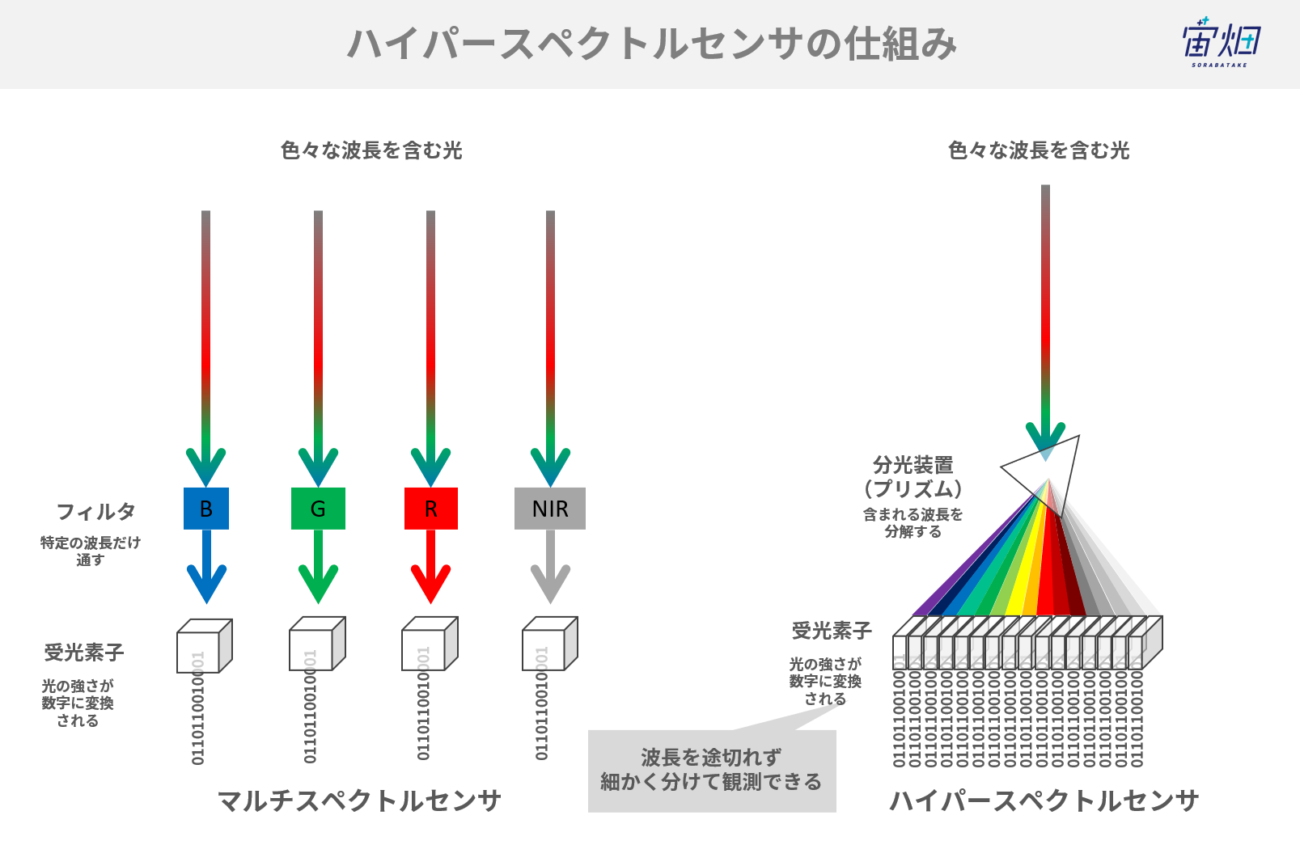
source: sorabatake.jp.
Why it's Important
Even just examining the image, it's clear that there will be benefits to this approach. The major benefits of a hyperspectral sensor are increased breadth of wavelength observation (we see more information for each band), better width fineness (each band offers interesting, discrete data), and wavelength continuity (there are fewer gaps between bands).
The following image cleverly illustrates the difference between the old and new approaches. On the left are the 4 narrow bands revealed by RGB+NIR. It's impossible to guess what the obscured figure might be. Increasing the number of bands of information leads to fewer gaps between the bands, which results in the figure on the right, which, while still obscured, is clearly an elephant.
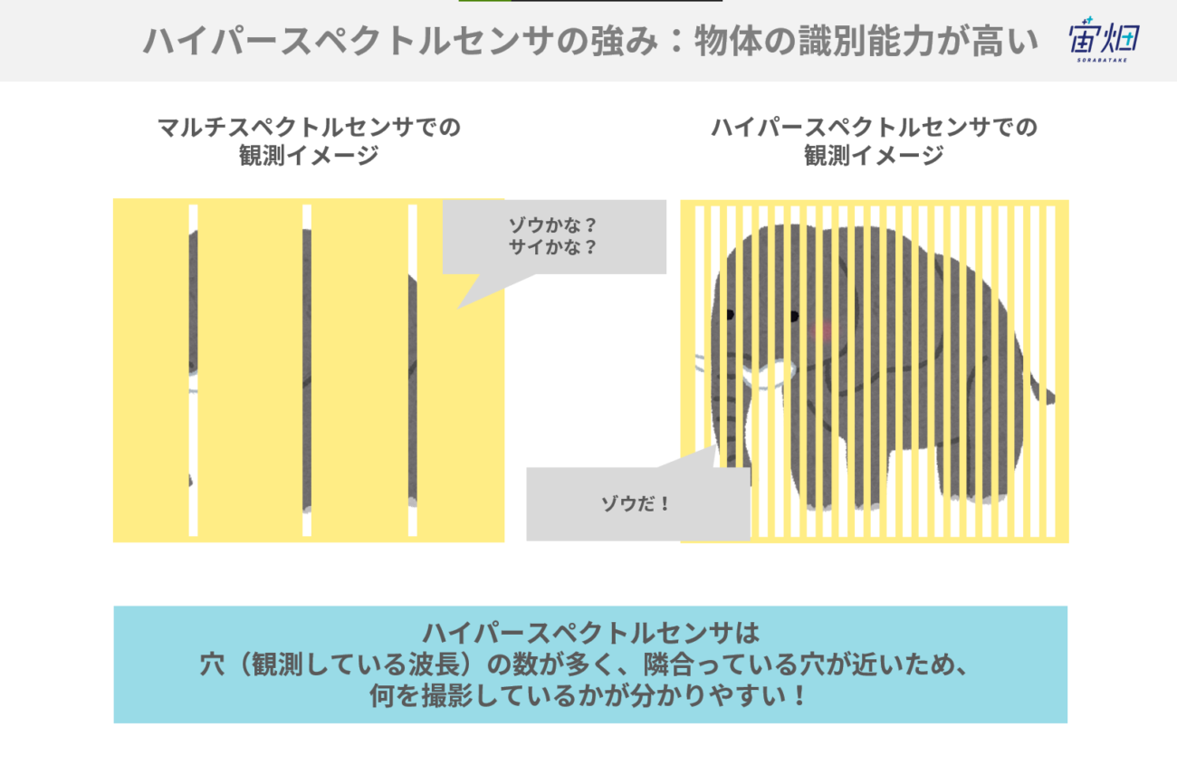
source: sorabatake.jp.
Practically, this provides much better identification of objects, as each object will produce a more distinct signature, as slight differences are amplified to the point of being observable. Hyperspectral imaging especially shines in places where objects are mixed. For example, images can distinguish between multiple kinds of plants in a field or snow on vegetation. Subtracting the differences between pictures from each other produces better results using fewer calculations.
Everything has a cost, of course. A key disadvantage of the hyperspectral technology is that making sensors to capture so much data is expensive. Manufacturers find make such mechanisms technically challenging, too. Another issue is that the increased bandwidth being observed requires larger hardware, leading to larger satellites, which are costlier to build, launch and maintain.
The increased data from more wavelengths being processed leads to difficulties in dealing with the data load. Satellites must either offload more data, usually to a cloud service, faster or process and store more data onboard the satellite. Wyvern, an Edmonton-based company, aims to do onboard processing, but space is a tough place to run computers.
Since previous technologies like SAR have been used for decades, there are many standard algorithms for cleaning and processing the data. Conversely, hyperspectral technology is new and distinct from processing previous optical sensor data, there are no clear guidelines for hyperspectral data use yet.
Practical Uses for Hyperspectral Imaging
The next section introduces three practical uses for hyperspectral technology: finding oil, agricultural analysis, and identifying mineral extraction sites.
Finding Oil
Hyperspectral analysis can reveal underwater oil sources. Since oil rises to the surface of water, scans can detect it as an oil slick. Previously, SAR measured the differences between radio waves reflected off water and oil to detect oil slicks. Hyperspectral data goes beyond SAR by more accurately pinpointing origin points. It can even detect whether the leak is natural or artificial.
Agricultural Analysis
We have been using satellite data for decades for agricultural purposes. By combining old and new data sets and with new algorithms and data analysis processes, agricultural applications are bearing increasing fruit (please pardon the pun!) Hyperspectral provides better data density with a single image, increasing the value of the data.
The image below is an analysis of distinct grasses via hyperspectral imagery. The single source image supplies detailed information about plant types and prospective harvest yields. When the central captured image is processed, the result is two images (left and right sides). On the left contains information about grass varieties (Timothy, Orchard Grass, Leadcutter Grass, Kentuky Bluegrass, Harugaya, Shiba wheat, Ezono Gishigishi, and Buttercups). On the right, they process the same image information into a yield prediction where red is better and purple worse.
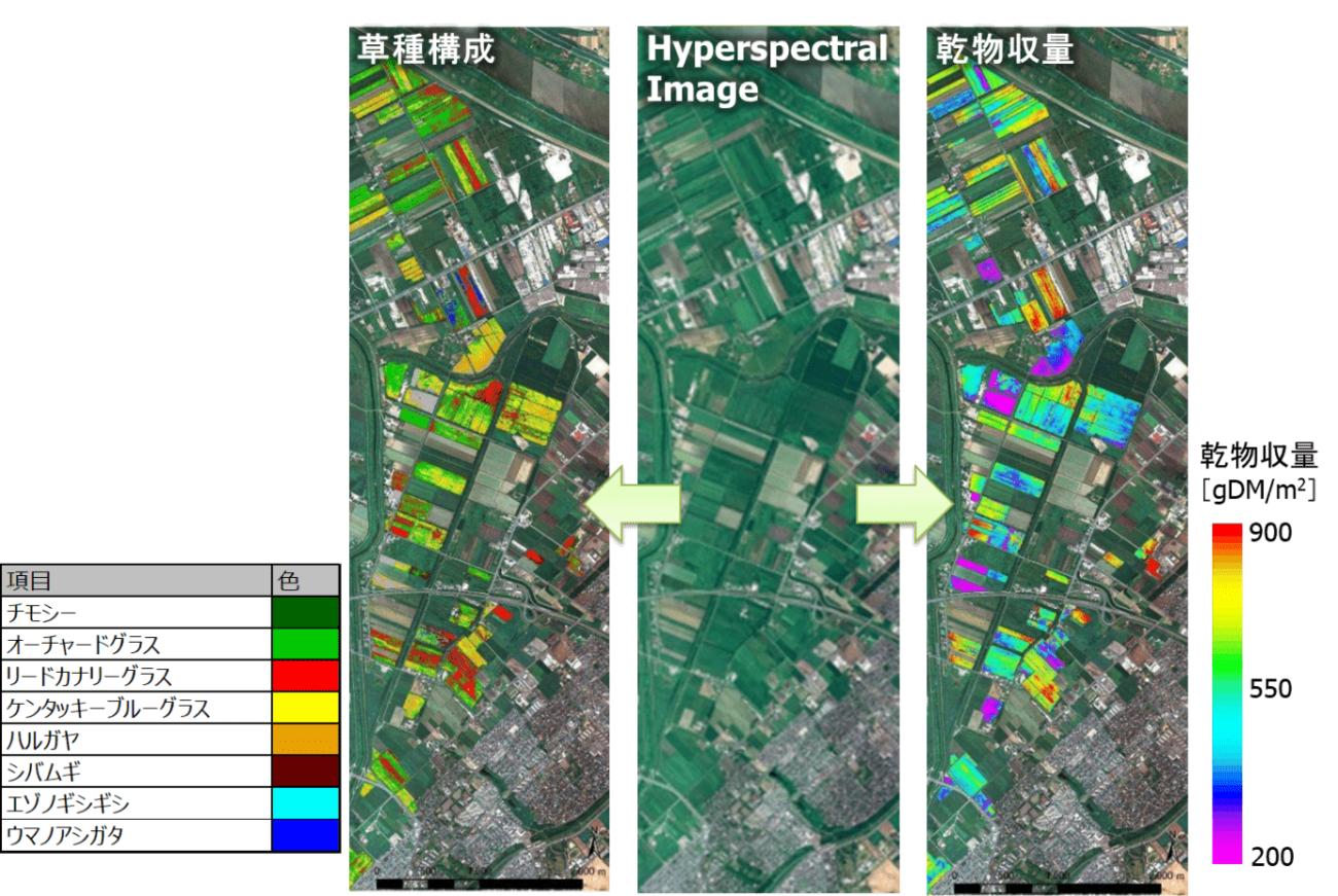
source: sorabatake.jp.
Mineral Detection
Hyperspectral imaging can identify and locate valuable minerals. This technology does not penetrate the ground, so at first glance, this seems impossible.
It works by capturing images of reflected light which can reveal the presence and size of various kinds of minerals on the surface of the ground. The presence of a particular mineral, especially when next to another (the top image below represents a satellite's view), suggests the presence of a third type of mineral hiding beneath. These regular types of deposits are especially found where magma has created the minerals. The regularity of magma structures helps geologists guess at even deeper and more valuable minerals below the surface level (the lower image below represents a cross section of a likely mineral structure identified from space).
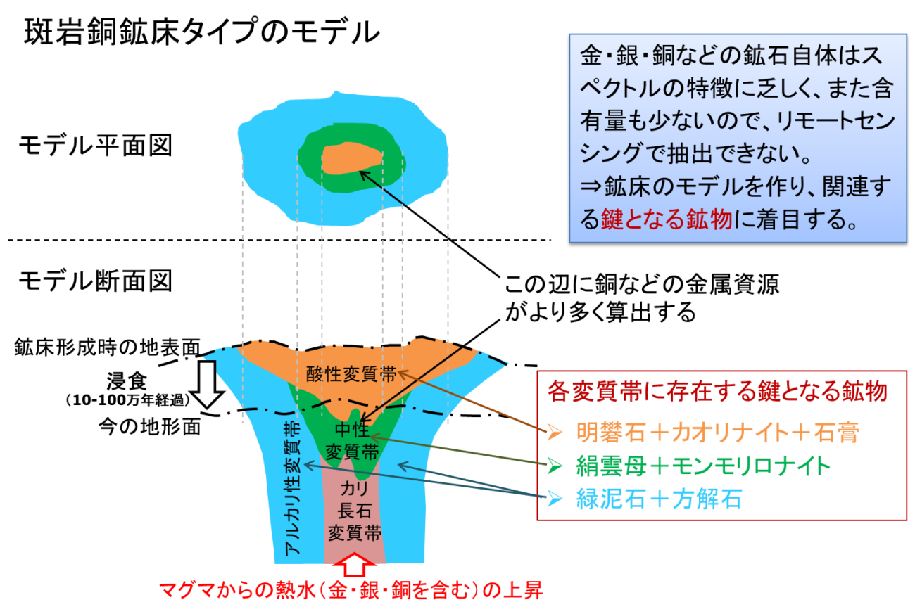
source: sorabatake.jp.
Conclusion
Hyperspectral imaging represents an important new technology in earth observation. While difficult to produce and lacking in established analysis techniques, the increased information the sensors provide already shows incredible promise in many areas, of which we explored just three in this post. Only a handful companies and countries can put a satellite into orbit with this technology today . Once the images are widely available, the techniques for analyzing them will improve rapidly and our understanding of the planet will grow in lockstep.
-
Bekdil, B. E. (2022, October 20). Turkey, Kazakhstan deepen relations in space tech, drone production. Defense News. https://www.defensenews.com/space/2022/10/20/turkey-kazakhstan-deepen-relations-in-space-tech-drone-production/ ↩
-
Somabata, Tachikawa, Takeda, Tanai, Kashimura, & Mao. (2022, October 12). ハイパースペクトルセンサとは~仕組み、用途、代表的なセンサ~日本の技術力が集結したHISUIの凄さに迫る!. 宙畑. https://sorabatake.jp/28639/ ↩